Teiki Mathieu Baillan surfing a self-made Alaya surfboard in Macaroni, Mentawaï, Indonesia. Photo by C. Naslain, 2009.
Aprecie e contribua!
| Achar os melhores spots |
|
|
![]() Central Group
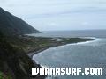
Central Group
Azores
English (Traduzir este texto em Português): <b>Central Group</b>: Terceira, Graciosa, Sao Jorge, Pico, Faial.<br /><br /><b>Terceira Island</b> is a Portuguese island in the Azores Archipelago, in the middle of the North Atlantic Ocean. Angra do Heroísmo, the historical capital of the Azores, is located in Terceira, and its historical centre is classified in UNESCO's International Heritage list.<br /><br /><b>Graciosa Island</b>, also known as White Island, belongs to the Central Group of the Archipelago of the Azores. The island has an area of 60,84 km² in an oval form. It has a length of 10 km and a width of 7 km.<br /><br /><b>Pico</b> (Ilha do Pico) is an island of the Azores noted for its eponymous volcano, its "peak" the highest mountain of Portugal.The island is 17.5 km south of São Jorge (Ilha de São Jorge) and just 7 km west of Fayal (Ilha do Faial). It is 42 km long, has a maximum width of 15 km and an area of 447 km² making the second largest of the Azores islands.
Variações sazonais de ondas e ventos:
English (Traduzir este texto em Português): Dominant swell= NorthWest-North all the year.Dominant wind= South-NorthWest from December to April. SouthWest-North from March to October
Mais informações
| Jan/Feb | Mar/Apr | May/Jun | Jul/Aug | Sep/Oct | Nov/Dec | |
|---|---|---|---|---|---|---|
| Best Surfing Season | 
|

|
|
|

|
|
| Typical Swell Size | 
|

|

|
|
|
|
| Surf Equipment | Springsuit | Springsuit | Springsuit | Shorty | Shorty | Springsuit |
| Water temp. | 16°C | 16°C | 19°C | 21°C | 22°C | 18°C |
| Air temp. | 15°C | 18°C | 24°C | 26°C | 20°C | 16°C |
| Climate | ||||||
Variações sazonais de ondas e ventos
English (Traduzir este texto em Português): Dominant swell= NorthWest-North all the year.Dominant wind= South-NorthWest from December to April. SouthWest-North from March to October
Este mapa é interactivo! Use os controles para fazer zoom ou para se deslocar.
- secções (1)
- viagens (0)
- Fotos (47)
- Vídeos (2)
- Compartilhe
- Favoritos
-
Os seus spots favoritos e as futuras listas de spots
Spots de surf
| Spots de surf (14) | Qualidade | Direcção | Tipo | Frequ | Experiência | ||
|---|---|---|---|---|---|---|---|
| Almoxarife | 1 / - | Direita e esquerda | Beach-break | 
|
Todos os surfistas | ||
| Baia das Quatro Ribeiras | - / - | Direita e esquerda | Recife de rocas |
|
Surfistas com experiência | ||
| Baixa da Vila Nova | 5 / - | Direita e esquerda | Recife de rocas |
|
Profissionais ou kamikazes... | ||
| Caldeira | 7 / - | Direita e esquerda | Recife de rocas |
|
Surfistas com experiência | ||
| Contendas | 5 / - | Direita e esquerda | Recife de rocas | 
|
Todos os surfistas | ||
| Faja dos Cubres | 6 / - | Direita e esquerda | Point-break |
|
Surfistas com experiência | ||
| Lagoa | - / - | Direita e esquerda | Recife de rocas |
|
Surfistas com experiência | ||
| Ponta do Queimado | - / - | Esquerda | Recife de rocas |
|
Surfistas com experiência | ||
| Ponta Dos Capelinhos | 1 / - | Direita | Point-break |
|
Todos os surfistas | ||
| Porto Martins | 3 / 1 | Esquerda | Point-break | Surfistas com experiência | |||
| Praia da Vitoria | 9 / 1 | Direita e esquerda | Recife de rocas |
|
Todos os surfistas | ||
| Praia do Norte | 1 / - | Esquerda | Point-break |
|
Surfistas com experiência | ||
| Punta da Caldeira | 2 / - | Esquerda | Point-break |
|
Surfistas com experiência | ||
| Santa Catarina | 7 / - | Direita e esquerda | Recife de rocas |
|
Surfistas com experiência |
 Comentários
Erros, Reacções
Você pode editar esta página para corrigir os erros e acrescentar novas informações. Se você tem outros comentários sobre esta página, Envie as suas observações
De JP , 05-06-2009
azores.... - Why are some people so angry in this messages. Azores has a lot to gain from turism, surfing on non-surfing, it brings money and jobs to the islands... and tourists have a lot to gain from the beauty of Azores