Teiki Mathieu Baillan surfing a self-made Alaya surfboard in Macaroni, Mentawaï, Indonesia. Photo by C. Naslain, 2009.
Appréciez et contribuez !
| Trouvez les meilleur spots |
|
|
 Sonomarin
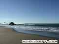
USA, California, Sonoma
Coordonnées GPS non connues! Modifier cette page et utilisez la carte interactive pour ajouter les coordonnées GPS du spot de surf !
Notation (2)
- Ajouter à mes spots de surf
- Commentaires (11)
- sessions (0)
- voyages (0)
- Photos (1)
- Videos (0)
- Partager
- Favoris
-
Vos spots favoris et futures listes de spots
Accès
|
English (Traduisez ce texte en Français): I want to say my buddy and I are the firsts to surf this spot, but I really have no verification. A hike is only way to the spot. And people from around the area may know where it is just by the name. It does have a specific name though, but I gave it its name because I think my friend and I are the firsts to surf it. DistanceA la journée ApprocheBonne marche (15-30 mn) Facile à trouver ?Difficile à trouver Accès public ? Accès spécialJe ne sais pas |
Caractéristiques du spot de surf
Qualité du spot
Quality des vaguesNormale
ExperienceSurfeurs expérimentés
FréquenceMarche de temps en temps
Vague
TypeBanc de sable
DirectionGauche
FondSableux
PuissanceRapide, Amusante, Slab
Longueur normaleCourte (< 50m)
Longueur max.Normale (50 à 150m)
Marées, houle et vent
Direction de la houleNord-ouest, Ouest, Sud-ouest
Direction du ventSud-est, Est
Taille de la houleCommence à marcher à et tient jusqu'à
Condition de marée
Mouvement de marée
Plus de détails
Fréquentation semainePersonne
Fréquentation week-endPersonne
Dangers
- Courants/Baïnes
- Rochers
- Requins
Informations supplémentaires
English (Traduisez ce texte en Français): It was cool when we stumbled across this spot. The waves were actually very good at about chest high with no wind, but a little bit of texture to water surface. We had our boards in the car so after watching the waves for about 10 minutes, we hiked to the car and got our stuf then hiked back to the spot. By that time the winds had picked up to the west. The session was still fun though, but not the same conditions as earlier the first time we arrived.
Atmosphère
English (Traduisez ce texte en Français): It was such a cool experience finding this spot, but I don't know if it has already been surfed. I felt like Craig Peterson(70's and 80's surf explorer), the isolationism was cool.
Général
Auteur: Anonyme Contributeurs (1)
 Commentaires
De anonymous , 16-09-2006
The Real Secret - You must mean the Petaluma river tidal bore. Paddle in at Black Point(under Hwy 37) and kick out in down town Petaluma!! It's shweeeet!
De anonymous , 20-10-2005
- Yeah you are right san antonio is the border at 101 But however somoma county goes farther south to the east the border at the coast is the Estero de Americano, there for youre spot should be called san antonio creek. Im pretty sure because i have a canoe on the estero and i can see it out my window.
Erreurs, Réactions
Vous pouvez corriger des erreurs ou ajouter de nouvelles informations sur cette page. Si vous avez d'autres commentaires à faire sur cette page, Dite-le nous.
Annonceurs
Wannasurf.com 24/24
Wannasurf.com sur votre portable
![]()
RSS Tous les flux RSS de Wannasurf.com
Newsletter Toutes les nouveautés par courriel
De Anonymous , 04-03-2009
sonomarin - alright, so we're both retarded. San Antonio is the border for the eastern half of the counties, and Estero Americano is for the western half. Anyway, my bet is that the spot he's taling about is Estero Americano-- I think its too hard to paddle down san antonio creek, and from google maps doesn't look like there's surf at the creek but there appears to be a sweet little line of whitewater at the mouth of the estero. Probably only works when the mouth is open though.